LA-Santa Barbara-San Luis Obispo-Morro Bay-Pinnacles National Park-3 nights at The Ranch-San Francisco-Sacramento-3 nights at Lake Tahoe-June Lake, Mammoth, Manzanar, Home Sweet Home.
I started this trip with a swing by the car place to get everything double-checked and to get a couple new tires. Then it worked out that I could see Nancy and Jim in Santa Barbara for a little while. I could have enjoyed just sitting in the garden admiring the birds. But we also went for a walk, so good for us!
Heading to San Luis Obispo over the Chumash Highway, I pulled off to stand for a few minutes amid these amazing trees and the wonderful smells of California Live Oak.
Strolling through downtown SLO I came across a tourist highlight, Bubblegum Alley. Wiki says this use of the alley was recognized either after WWII or in the 1950s but at least by the 1970s it was a well-established Happening Thing.
.
I was hoping to get into the Mission in SLO since I can’t remember ever having been in before but today was not to be the day. They are still doing mass out here in the garden. Mission San Luis Obispo de Tolosa was founded by Spanish Franciscan Father Junipero Serra in 1772, fifth of what was to become 21 missions on the El Camino Real, running along the California coast from San Diego to San Francisco. A little perversely maybe considering my feelings about religion…I seek out these missions just like when traveling I always want to find the cathedrals. Long story I suppose, but I Think I do know why. I’m going to make a list!
They’ve got a pretty big college here, the California Polytechnic State University, San Luis Obispo, established in 1901, a golden oldie with 22,000 students enrolled. SLO, with a city population of around 50,000, does the 50k include the 22k? I don’t know, but in either case the population skews very young. This is evident by the downtown commercial properties being predominantly bars, restaurants, and clothes for college-age souls.
There was a month-long Let’s Have Flowers event which was fun.There’s a creek down there and it creates a lovely place to walk and find some shade in the summer.The creek runs down there too, between the bushes and the stone wall, you can’t see it, and the mission is there behind the plaza. I sat out here and enjoyed my book and a glass of surprisingly good College Bar wine.The setting here in SLO is really quite pretty so if you’re ever rolling along the 101 you might consider a stop. And the Madonna Inn is just down the road…
What a delightful day with Becky and Jack at their beach house in Morro Bay!
.
The weather was perfect, cool, bright, fresh, perfect. We had a yummy lunch……in this harbor where we enjoyed a beautiful stroll on the boardwalk through a bird sanctuary and you know how much I appreciate a boardwalk.And from everywhere, views of The Rock.We took a short walk down to a protected rookery. Notice all the nests…
And we had to swing by the big entertainment of the past week – The Dredge. This guy comes by once a year to dredge out the harbors and then build the protective banks. (There is a vocabulary word that is escaping me right now. Yikes!)It was from here that we walked over to The Dredge and then on to The Rock to watch the otters. I’m not sure if the walking trail goes all the way around but it looked intriguing as do many other walking trails in the area. Thanks guys, it was great and congratulations on your awesome home. Jack, Becky, me, on the balcony at Casa Brand.
First I’m going to make a map. I ‘think’ I’ll have time for that before it’s time to EAT AGAIN. omg The Food here at The Ranch.
An overview of where Pinnacles is:
And a closer view to appreciate the long and winding roads.
Notice how the two sides of the park, the East and the West Entrances do not join. Just one of the reasons I’ve never been to the West Entrance, the whole point of this little sojourn. Google offered me a nice short alternate route to get from the West side to the East. What Was Google Thinking?!
I traveled 14 miles on a rutted dirt road with crazy-sharp switchbacks up and down through the mountain. What?! YES! I wanted to drive on roads unknown to me but maybe not quite that unknown.
Leaving King City at 6:30am heading into the West Entrance where I have never been. I filled the tank with gas in King City so as to be sure not to repeat a previous episode when I got lost going to the ranch and arrived on fumes. Fortunately Jerry keeps a gas station on the property but I hope, if at all possible, to never repeat that embarrassment. Here I am turning onto Highway 126 from the 101.Along the way I passed many fields… And vineyards. It was a lovely ride.The main activity at Pinnacles National Park, from both sides, is hiking which usually involves some scrambling and climbing, and also repelling is popular. I asked a couple of guys at the parking lot who were loading up their gear, how long would it take to get to where they were going. Oh about 45 minutes of hard slog. Not surprisingly, not for me!I did stroll along a little for this view, just my speed. I was concerned by the huge blinking sign at the entrance declaring one might expect a 1-2 hour delay due to the one-lane road ahead. I was there so early I had no problem but people kept arriving and I thought I might as well head out.Check this, a cloud lake! I am about to hit the dirt road. I’ve asked google a hundred ways and I can’t find anything to tell about that dirt road and I was too absorbed in No Falling that I didn’t take any pictures. Oh well, I’ll not be on that road ever again anyway.Into the more developed East Entrance I chose this place to consider a stroll. The mileage markers are the distance to the trail head. Not one of the hikes was ‘easy’, ‘moderate’ was the least challenging and knowing what the Park Service considers moderate “appropriate for children” I just went a short way in and turned around when a family with three wailing children passed me on their way down.The distance I did travel was lovely. I had been on one of these trails before, leading to the dam and a cave. I remember, it was beautiful.One of my goals was to find a quiet comfortable shaded spot to settle down and listen to the surrounding landscape, but it was not to be. There were people, and rocks really are not that comfortable.Views aplenty though.
Here’s a little wikipedia about the Park and why you might not have heard of it:
“The national park is divided by the rock formations into East and West Divisions, connected only by foot trails. The east side has shade and water, the west has high walls. The rock formations provide for spectacular pinnacles that attract rock climbers. The park features unusual talus caves that house at least 13 species of bats. Pinnacles is most often visited in spring or fall because of the intense heat during the summer. Park lands are prime habitat for prairie falcons, and are a release site for California Condors that have been hatched in captivity.
“Pinnacles was originally established as a national monument in 1908 by President Theodore Roosevelt, and was re-designated as a national park by Congressional legislation in 2012 that was then signed into law by President Barack Obama on January 10, 2013.“
Above, part of the olive tree lined driveway into the ranch, and below, the entry gate.
For the welcome first night’s Friday dinner we always have Shabbot with candles and prayers, songs, and challah with wine. Tradition! Bill and Rita always bring duck from Chinatown and make a vegetable stir fry. We always have salmon, this time prepared by Nana in Japanese style with another vegetable dish and rice. Sandy made poppy seed cake with whipped cream and fruit.EAT is right. Oh my goodness. The food is so tasty and so very much of it and proffered so very often mostly by Barbara and Jerry but everyone has something to offer. The cooking and clean-up, no surprise here, is held up primarily by the women in attendance. This is the other main eating venue. Lunch is always out here, and also the traditional BBQ FEAST on Sunday night. There’s a large and fully stocked kitchen there to the left and the BBQ area is down the path past the fence.
Samara, Sandy, Lewis, Lynn in the Dining Hall.
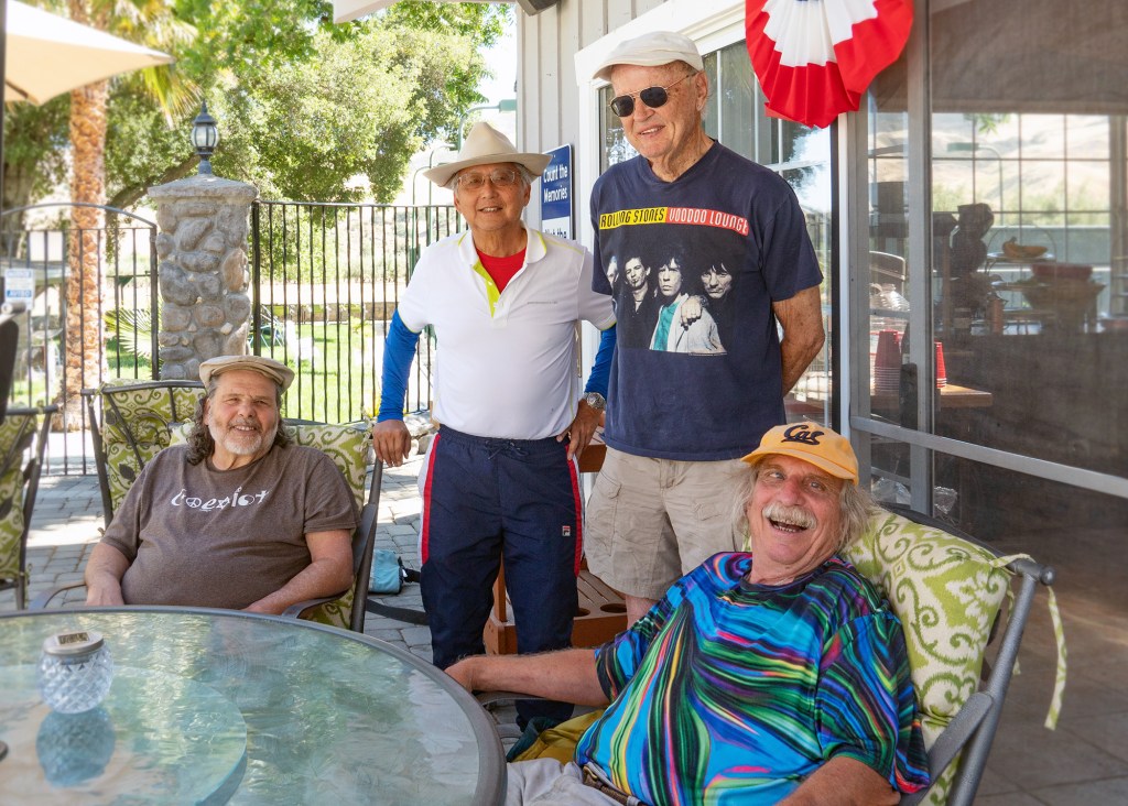
Bob, Bill, Dennis, Carl at the Pool House.
This was an unexpected and delightful addition to the program. Ian and Nana and their fabulous baby who I enjoyed Every Day came in from their home in Japan. Here is Nana making us all Japanese tea with a delicious selection of snacks she brought from Japan, and cookies she had made the night before, all served up in the new family dining room. You go!
Jerry’s Garden…GROW!Naomi and Rita. So many sporty activities for the guests to enjoy. Tennis, basketball, ping pong, swimming, hiking, yoga, what else? added to a barn full of indoor games such as skee ball, foosball, pool, and more.
And then there’s the spa! Lynn, Naomi, Marijke.
Everyone takes The Walk at least once per day, a one mile stroll (or power walk or run…) around the olive groves with much to be seen and enjoyed along the way.
I was so excited to see these cherry trees thinking Hanami might be in my future but Jerry fears they’re not going to make it. Fingers crossed for someday a canopy of cherry blossoms.
This is here as an example. Everywhere Barbara goes she comes home with trunks full of amazing things, things that one finds in every room of the property.Lots of cars this year.
And below, Inside and Outside my front door.
Here and below, some pictures from around:
Ben and Bonnie enjoying these amazing better-than-a-hammock things. We took a picture of the label but I don’t think it will be too much help since it only gives an address in China.
Here’s me taking a turn. So even if we could find them to buy we couldn’t buy this view!
And below, I’m closing with the group shot from Saturday’s Entertainment Night. I hope to get a few pictures from the others of the bits I missed (Bonnie…). Bill, Jerry, me, the baby (get the spelling!), Nana, Lewis, Barbara, David, Naomi, Lynn, Carl; Ian Dennis, Samara, Rita, Ben, Bob, Marijke, Bonnie. Missing: Sandy, Dusty and his two boys.
My swing through San Francisco was actually a few hours visiting with Roger and Sandy and I was so glad for it. I hope I didn’t do them in…both remarking upon their need for a nap!
The above picture is of Sandy’s recent work from a class, building art inside a small box. Of course Sandy being Sandy, she searched through antique stores to get just the perfect boxes. Below is a picture of a part of two of the many walls covered in her art.
Roger has been doing Uber Eats for some work these days and he doesn’t seem to mind terribly – he likes making people happy when he brings them what they want. He enjoyed it very much when his phone binged indicating a tip had come through, and he brought delicious treats from a nearby bakery, and he made us a chicken salad. Thank you Roger!
Sandy gave me one of her paintings! She had done the painting years before and recently added the frame. I LOVE it! It’s Nancy on the left, me in the middle, and Sandy herself on the right. Isn’t it fabulous!
.
We went for a short walk around the ‘hood, this is inside the community garden. We think that’s some mutant Swiss chard, Roger and Sandy for scale.This picture is one in a series of recent collages on the theme of New York New York (it’s a helluva town). I’m still planning to go there soon…
I want to add one of Sandy’s poems. She used it as a contribution to Roger’s Voices of Humanity discussions and it was a big hit. You can click on over and join in too.
Looking for My Nitty Gritty
Still with the wounds that come with age (and I’ve had my share)
Years of discovery and recoveries Of digging and pealing at the truth To get to the core, the heart, My own Nitty Gritty
Years with my hands in the dirt Scuffing and chipping my Nails to behold the tuber That started it all
I haven’t seen her for a while My Nitty Gritty
I wonder, is she near, is she close? Is she in something I do Or make?
In a painting, a collage, a drawing Of a wavy headed girl, In a poem I am writing?
In something I wear That takes flight? Like my Mexican twirl skirt, A patchwork of colors, bold and muted With ancient Aztec and modern designs?
Is she in the kitchen, in the fruit That I sliced and put in a Bowl to eat now or later With crumbly cheese? In the apples Simmering in a pot with cinnamon And cardamom?
Is she outside Wrapped in a tea towel And left by the door?
What could be easier? I’m always here Opening and closing cupboards and doors, Sweeping and fixing, Hammering nails Watering and wiping Metal and glass
Back in the kitchen I sift flour with baking Soda and salt Whisk butter and sugar, Eggs and vanilla, Folding the wet with the dry Kneading the dough
Still wondering – Is she hiding under the sink? Among old plant containers and worn out Sponges, jars with lethal Smelling Substances Things you don’t want to touch Or get into your eyes With left over dirt Like the stoic cat in a Repetitive dream That hasn’t been fed or Brushed in years But continues to live in spite of neglect
Am I the cat? Am I the Nitty Gritty? Am I the tuber? Am I my thoughts? And wonderings?
Tired and spent I rest to still my mind Awakening to the fragrance of baking dough I smile, forgetting my Nitty Gritty
I walk outside and squat in the Garden Giving the half eaten pear on the cutting board, Its flesh turned brown, A new home on the compost heap
Above is the view from my hotel window. I had to change rooms three times but it was worth it considering the two other views were commercial roofs full of air conditioning units.
Rolling into Sacramento at 5:30p the temperature was 110. The following day it was 97. Nice as Sacramento is, but yikes.
.
My hotel is positioned exactly where I wanted to be, right between Old Town and the Capitol. Coming onto the plaza, here’s the divider:
Following under the gate to Old Sacramento we pass through an underpass..
..leading right into Old Town.
I got up at 6a to have a nice stroll before it got too hot and bonus, it was so pleasantly quiet without people or cars.
I stopped in Sacramento for a chance to have a visit with Christa, to have a rest day on the trip, the timing between destinations was good, and I like Sacramento.
Me and Christa, then and now. Christa took me out for lunch – she’s got a real job and she wanted to pay! Thanks sweetie!!
Here is where Christa lives, her block, looking up the block and across the street. Sacramento, City of Trees.
The gang from my visit to Sweden reassembled itself here in Lake Tahoe! Jim, Baby, Rick, Lill, Tony. They drew that dog ‘tattoo’ on their arms to send to a friend who, during a game of Pictionary, drew this very dog for a dog…and will never Ever live it down.
WEDNESDAY June 2
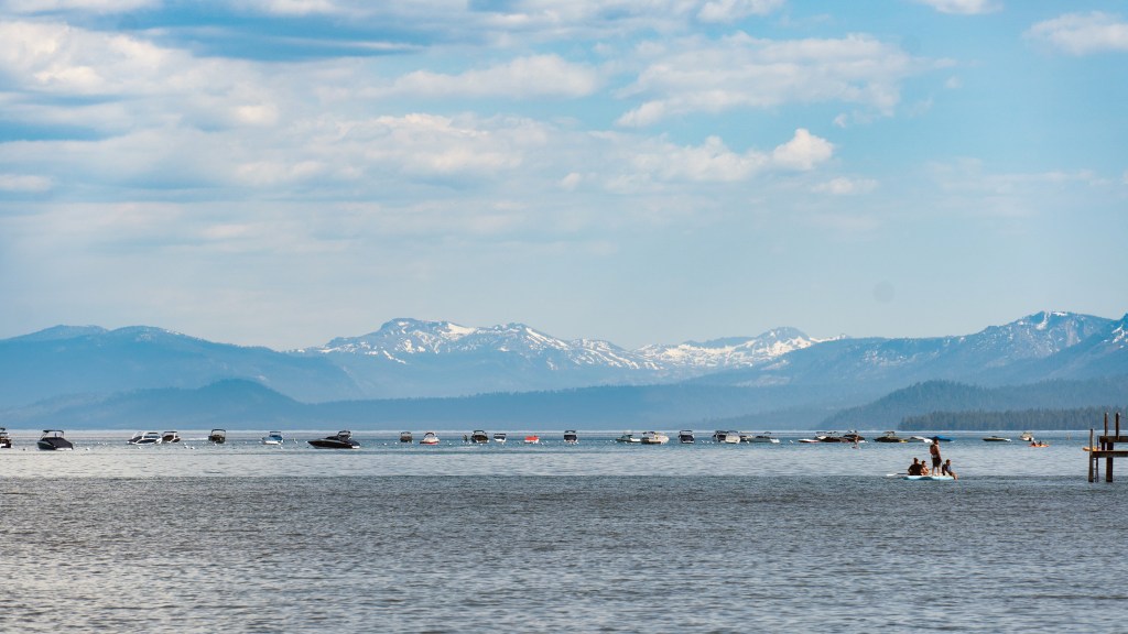
I arrived from Sacramento just in time to join in for a late lunch and then we went to the nearby town of Tahoe City. As well as shops and restaurants, they have a nice public beach there and a very nice walking path.
Later in the evening we went down to the private beach connected to the complex where we were staying at Dollar Point.
The dock above belongs to the next door complex. I seem to have missed a picture of our beach I guess because I got too excited over this bird. ND found it on the internet, a sweet little Barn Swallow.
.
THURSDAY June 3
We left early to visit Virginia City, Nevada. These pictures are all from the internet because there were so many people and so many cars I wasn’t happy with any of my own. Virginia City was developed overnight in 1859 with the great silver discovery of the Comstock Lode and now it’s a full-on tourist town. Not like Colonial Lynchburg for example because the refurbishment efforts have been minimal which added to the charm (although I should note that all the trumpiness did give me a bit of a shiver).
This is the larger of the two, the Catholic church that is in good enough condition and open for services and visitors.The Episcopal church on the other hand was in very bad shape and they were not able to hold services in the main areas but they did have a little rec room space on the floor below, with 10 chairs and a microphone. The church was actually closed, but Rick and I lucked out in that a woman with a key was puttering around outside and she let us in.After visiting Virginia City (and it was HOT btw) Rick drove me and Baby back ‘the long way’ so we could get a feel for South Lake Tahoe (we are north on the California side in the quieter area), and catch a glimpse of Emerald Bay.
Evening fun!
FRIDAY June 4
For orientation, notice the dotted line that separates California and Nevada.
We did two easy walks in the morning, chosen for me I’m sure because Rick, Jim, Lill, and Tony are Hikers: big boots, two walking poles, quarts of water, see you in several hours.
First stop, a lovely meadow boardwalk.
From Rick on his phone, ‘so I can get a picture of me right away!’
The back side of our unit. We had a four bedroom condo on three floors with everything one would need to cook in, which we did for all but one meal. What a good job you guys!
.
SATURDAY June 5
That’s our condo behind Lill’s head. Goodbye all, it was FAB!
(hey google take selfie)
.
Other People’s Pictures
LILL: our back balcony from before I arrived, the gang enjoying a lightening storm! We also got one fabulous view of the International Space Station and one less fabulous view. That ISS moves Fast, orbiting the earth every 90 minutes. When you can see it, it’s unmistakable. This website will tell you where it is: https://spotthestation.nasa.gov/tracking_map.cfm
Mono-June-Mammoth Lakes, Manzanar, the Alabama Hills and various amazing landmarks.
SATURDAY June 5
Leaving California at the north end of Lake Tahoe I took a very short detour once in Nevada to have a roll through Carson City knowing I’d get the cheap gas and in hopes of seeing the capitol building. Thumbs up on both goals.
After I drove away I thought I should have parked and had a stroll. But it was Hot, so there’s that. wiki: “The city is in a high desert river valley approximately 4,802 feet with cold winters and hot summers.” Truly true.
.
First stop, Mono Lake, from a view point off the highway.
“The desert lake has an unusually productive ecosystem based on brine shrimp, which thrive in its waters, and provides critical habitat for two million annual migratory birds that feed on the shrimp and alkali flies. Historically, the native Kutzadika’a people ate the alkali flies’ pupae, which live in the shallow waters around the edge of the lake.
“When the city of Los Angeles diverted water from the freshwater streams flowing into the lake, it lowered the lake level, which imperiled the migratory birds. The Mono Lake Committee formed in response and won a legal battle that forced Los Angeles to partially replenish the lake level.”
.
I couldn’t get the good picture, I’m there at noon, I’m sweltering, and oooh the stink and the flies…
And here’s a little excerpt: “All tufa at Mono Lake forms underwater. Beneath Mono Lake, calcium-rich freshwater springs seep up from the lake bottom and mix with lake water rich in carbonates (think baking soda). As the calcium comes in contact with the carbonates in the lake, a chemical reaction occurs, resulting in calcium carbonate, or limestone. The calcium carbonate precipitates (settles out of solution as a solid) around the spring, and over the course of decades to centuries, a tufa tower will grow. Tufa towers can grow to heights of over 30 feet underwater.”
It was at this point, after an hour in the blazing baking burning blinding sun, when I couldn’t complete the walk because of the heat, (YAY I turned back in time!) that I decided to absolutely drink more water. The gang at Lake Tahoe, each one separately and often together urged me to drink more water. Drink More Water. Fine.
Not my pictures: Grant Lake with a small cabin complex and accessible beaches; June Lake that I remember as a beautiful and peaceful alpine retreat was none of those things; one of the Mammoth Lakes that I never found.
SUNDAY June 6
I left the Mammoth area around noon having spent the morning trying to get through the Lake Tahoe pictures and then decided on a visit to Manzanar.
Both Dorothea Lange and Ansel Adams spent many months at war-time Manzanar making photographs with very different outcomes. They both worked under strict regulations, no photos of barbed wire or guard towers or military police or anything negative really. Lange was first and from what I read much more gritty and also censored whereas Adams’ work was widely criticized for being simple propaganda.
“Dorothea Lange, “Manzanar, California, Dust storm at this War Relocation Authority center where evacuees of Japanese ancestry are spending the duration” (July 3, 1942). The area was subject to extreme seasonal temperatures, with dust a constant presence due to the high winds. Incarcerees often awoke mornings covered in a layer of it. (photographed by Dorothea Lange for the WRA, courtesy the National Archives [Archives Identifier 539961])”
.
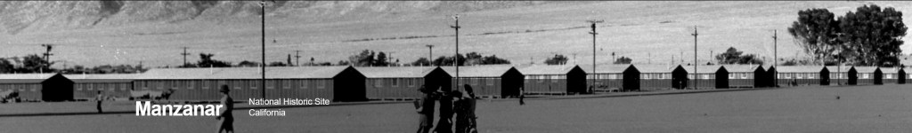
Having several times visited the very extensive exhibitions at the Japanese American National Museum in downtown LA I wasn’t particularly anxious for more Manzanar but actually I’m glad I went.
The visitor’s center was closed but the driving-around tour was open and you could get out along the way. It was standing there that was so physically overwhelming much like the photo above – so hot with a furious hot dusty wind and I got a more visceral feeling for the enormous scale of the place (only 5th in population size of the 10 internment camps).
It looks mostly like this now, with a very few buildings, mostly desert and signs about what was there during the war.
Instead of trying for the Alabama Hills this afternoon I decided to check into my motel in Lone Pine and find a nice big western dinner, full service, wine, lots of courses.
And I did. And these walls? There were more!
MONDAY June 7
The last leg of the trip, before home sweet home tonight. But first I want to take a spin through the Bureau of Land Management recreation area called The Alabama Hills, but first before that, I missed the turn off and ended up at the Mount Whitney trailhead!
UpUPUP. I knew at about 7,000 feet that I had made a mistake but why not follow it through to the 8,600 feet trailhead. I left the motel at 5:30am (that’s right, HEAT) so when I got up there it was still early enough to see Hearty Youth packed up for the assent to 14,500 feet.
On the way down I found the turnoff and spent some time admiring the formations of the Alabama Hills.
“The Alabama Hills are a formation of rounded rocks and eroded hills set between the jagged peaks of the Sierra Nevada and the geologically complex Inyo Mountains. Both geologic features were shaped by the same uplifting occurring 100 million years ago. Visitors enjoy touring film sites, photography, rock climbing, exploring natural arches, and viewing the swaths of wildflowers that bloom every spring. Horseback riding and mountain biking are popular activities.”
And after 5 stops to pee (remember? Drink More Water?) I was Home Sweet Home!